Thursday, January 31, 2008
See the Golden Gate Bridge from a helicopter
I wish I could say I shot this video, but I didn't. I found it on YouTube. It was produced by Sandra Cannon for www.sfbayimages.com. October 2005.
I bought the bridge for $1000


I met a real nice guy on the bridge. He sold it to me for only $1000.
But seriously, this is a cancelled $1000 bond that was originally issued on July 1, 1933. They sell them as souvenirs in the gift shop next to the bridge. They're really interesting looking and there are signatures on the bottom from the president and secretary of the board of directors.
Me on the bridge
 There's a civil war era fort under the bridge!
 I walked as far as the first tower. It was windy and noisy from all the traffic. The view of the city skyline was obscured by haze. It's a LOOOONG way down!
The Golden Gate Bridge


This large cable is actually made up of hundreds (maybe thousands?) of thin cables, no bigger than the thickness of a pencil
2 or 3 hundred elephant seals! I can't remember how many
 The park rangers really do count the number of elephant seals and post it for all to see. This is the prime season for babies to be born. If I remember my statistics correctly, the babies weigh about 70 pounds at birth, and by the time they head back out to sea when they're about 3 months old they weigh 300-350 pounds!
A crew from one of the San Francisco TV stations was just leaving when we arrived. I caught the story on the news the next morning and we must have just missed a couple of bull elephant seals fighting. They weren't very active when we were there.

Here's what it looks like going back up!

The steps have numbers painted on them about every 50 or so, either to torture you mentally, or to help you pace yourself.
Thar be whales!
We feel very fortunate to have caught a glimpse of several gray whales on their southern migration. But let me tell you, it's no fun to look at them through a camera viewfinder. And by the time I reacted, found the whale in the viewfinder, squeezed the shutter and waited for the camera to do its thing, I had many wasted shots. And as the angle of the sun changed it became increasingly difficult to see anything through the viewfinder.


Only 302 steps to the lighthouse!

Notice the yellow warning sign! They're not kidding! It's way more fun on the way down.
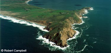
Point Reyes National Seashore

We drove CA-1 from Muir Woods to Point Reyes. What spectacular scenery! What a scary road! Well, not really. But there weren't many places where the road was straight! After we got to the Point Reyes visitor center it was still about a 35 minute drive to the parking lot, a .4 mile hike up a fairly steep incline where I took this picture. This is very similar to the view from the Point Reyes webcam I posted earlier (scroll down).


Thursday, January 24, 2008

Hummingbird on Alcatraz island


Alcatraz was incredible! The audio tour is fantastic! After touring the prison, Susan and I began walking the trails on the island. I heard a very faint bird song, and when I looked around I saw this tiny little hummingbird sitting on the barbed wire. My first few photos of him (her?) were backlit, so I only got a silhouette against the blue sky. He flew away, but soon returned to about the exact same spot. I was able to sneak around to the other side of him where the lighting was MUCH better and take a few more photos before he left for good. I'm guessing it's an Anna's hummingbird. A website I consulted said it's the only hummingbird to be found in California in the winter.
The wild parrots of Telegraph Hill


I first learned about these colorful birds while watching a fascinating documentary on PBS. I consider myself very lucky, because when I got to Coit Tower, several of the birds were eating berries in one of the trees. I got to within 5-10 feet of them to take these photos. A few minutes later another tourist startled them and they flew off.
Also see this website for more info: http://www.pbs.org/independentlens/wildparrots/
Wednesday, January 23, 2008

Tuesday, January 22, 2008
Flying over Alcatraz

Special thanks to my son for staying up VERY late Wednesday night (Thursday morning) to capture this shot of our jet "flying" over the Bay Bridge and Alcatraz in Google Earth.
San Francisco is at the top of the photo. Alcatraz is above and to the right of our plane. The little colored dots are icons representing pictures that can be viewed of those locations in Google Earth.
GPS data in Google Maps
As I explained in an earlier post, here's the data from the handheld GPS receiver. The GPS could not get a signal in the Muir Woods because of the thick canopy of the trees. I forgot to take the GPS with me on some of my sightseeing in downtown San Francisco, so you won't get to see the many streets I explored either on foot, cable car, or bus. But I did include our trip to Alcatraz. You can zoom in or out on the map below using the controls on the left side.
Point Reyes/Alcatraz at EveryTrail
Map created by EveryTrail:Share GPS tracks
Point Reyes/Alcatraz at EveryTrail
Map created by EveryTrail:Share GPS tracks
Point Reyes lighthouse video
I just discovered this today! It's a short video on the Point Reyes lighthouse from the Discovery Channel.
Monday, January 21, 2008
Sorry I haven't blogged, but...
...the Internet was ridiculously slow, and while I worked on a post on Friday morning and started to upload a photo, POOF! the Internet puked. I decided I would much rather ENJOY my vacation than to be a slave to the computer. So I hope that over the next few days (weeks?) I'll be able to bore you with several stories, anecdotes, photos and maybe even a video or two.
BTW, SFO was incredible! I wouldn't want to live there (nor could I afford to!), but it's a fantastic city and surrounding area to visit.
And MAN did my feet hurt!
BTW, SFO was incredible! I wouldn't want to live there (nor could I afford to!), but it's a fantastic city and surrounding area to visit.
And MAN did my feet hurt!
Tuesday, January 15, 2008
Our (Jim's) itinerary
Wednesday: Leave DTW at 4:20 PM, arrive SFO 9:40 PM after a 2.5 hour layover in Chicago (MDW).
Thursday: Muir Woods and Point Reyes National Seashore
Friday: Tour AT&T park, Coit Tower, North Beach, Beach Blanket Babylon
Saturday: Chinatown, Embarcadero, Fisherman's Wharf
Sunday: Alcatraz tour, ???
Monday: Leave SFO 7:25 AM, arrive DTW 6:35 PM after a THREE HOUR layover in Chicago!
Track our flights on a real-time map at www.fboweb.com Enter the airline and flight number on the left side of the page where it says Quick Track (FREE!)
Wednesday: Southwest 1343 Southwest 2987
Monday: Southwest 953 Southwest 1465
If you have Google Earth it's even cooler! Just click the "Track in Google Earth" button on the map page.
Remind me to tell you all about our hotel reservation "problem" when I get back. Just keep your fingers crossed and say a little prayer that we really do have a room when we get there late Wednesday night like the lady from Jensen said we would.
Monday, January 14, 2008
I LOVE this photo!

It's a picture of the Point Reyes lighthouse by Kathi Kaiser, posted on Panoramio and selected for viewing in Google Earth. I hope I can take one very similar to this when we're there on Thursday. It's about 300 steps to the bottom.
I need a pack mule!
Here's a list of all the tech stuff we'll be taking with us:
1 laptop
1 Palm handheld computer
1 handheld GPS receiver
1 car GPS receiver
1 digital camera
1 digital camcorder
Spare rechargeable batteries
Cables and accessories for the above
I'll be using the Palm to run a free program called Metro. It has a list of popular tourist attractions and how to navigate between them on the buses, cable cars, streetcars, and subways in San Francisco. I've used the program before in Chicago, New York and Boston and it really works!
Friday, January 11, 2008

KQED: Lonely Island, Hidden Alcatraz
Check out this fantastic website about Alcatraz:
http://www.kqed.org/w/alcatraz/flash/movie.html
http://www.kqed.org/w/alcatraz/flash/movie.html
Alcatraz Island multimedia

Some great photos on the National Park Service website. Click the hyperlink above to see them for yourself. The virtual tours are especially cool!

San Francisco weather forecast
I don't know if this photo will automatically update each day, but I hope this forecast from KPIX is correct:

Wednesday, January 09, 2008
PhotoMapper Rocks!


I'm interested in "geocoding" my digital photos. I learned that there is software that compares the time encoded on a picture with the time in a track log on a GPS receiver, and then the software places the picture where it was taken in Google Earth and/or Google Maps.
So while reading the GpsPasSion blog I learned about FREE PhotoMapper software that does just that. Quite easily I might add.
So while reading the GpsPasSion blog I learned about FREE PhotoMapper software that does just that. Quite easily I might add.
The first picture is a screenshot of the software. On the left side is a list of digital pictures, on the right is the GPS tracklog.
The second picture is of Google Earth with the geocoded photos located almost exactly where they were taken. I haven't figured out why some are in the wrong location. But as easy as this was, and for FREE, I'm not complaining!
Tuesday, January 08, 2008
Happy 100th Birthday Muir Woods!
January 9, 2008 is the 100th birthday of Muir Woods, another National Park we'll be visiting. Check out this web page for more info: http://www.nps.gov/muwo/planyourvisit/muir-woods-centennial.htm
A few years ago I visited the Big Basin Redwoods State Park and I was in awe of the gigantic redwoods. But Muir Woods is only 12 miles north of San Francisco, and from there we can continue on to the Point Reyes National Seashore.
Here's another interesting site to visit to learn more about how we can all help to preserve our nation's remaining redwood forests: http://www.savetheredwoods.org/
And here's another Google Map to check out:
Point Reyes National Seashore
I can't wait to go to the Point Reyes National Seashore! This is an excellent location to watch migrating gray whales, and elephant seals. We'll be driving right along the San Andreas Fault to get there!
Play around with this embedded Google Map.
Earthquake mashup
Although I can't get the embed code, here's a link to a map of the San Francisco area with a mashup of USGS earthquake data from the past week. If you zoom out far enough on this map you'll see color-coded circles that represent the strength of the seismic activity. Pray that we won't have any while we're there!
http://maps.google.com/maps/mm?ie=UTF8&hl=en&ll=37.859676,-122.603302&spn=0.446705,0.885773&z=10&om=1
http://maps.google.com/maps/mm?ie=UTF8&hl=en&ll=37.859676,-122.603302&spn=0.446705,0.885773&z=10&om=1
Getting ready for SFO!
While we're in San Francisco, I'm going to attempt to show you EXACTLY where we were by using a Garmin GPS unit, some cool FREE software, and an AWESOME free website.
The software is called EasyGPS and it allows you to download the data from the GPS unit and save it as a GPX file.
The website, GPS Visualizer, takes your uploaded GPX file and creates a "mash up" in Google Maps to display a map of exactly where you were. GPS Visualizer now has a partner website called Every Trail that saves the mash up and generates the necessary HTML code that enables you to embed your Google Map on your blog. Like this one:
Sample1 at EveryTrail
Map created by EveryTrail:Share GPS tracks
Subscribe to:
Posts (Atom)
